Peru has the privilege of possessing one of the richest portions of the Amazon ain the world. However, for the traveler planning their adventure, choosing the right destination can be overwhelming. If you are wondering which best peruvian amazon region to visit, you are not alone; this is the most frequent question among our passengers before booking.
Each destination has its own magic, accessibility, and type of wildlife. In this article, we will break down the real differences between the three great titans of the Amazon: Tambopata, Manu, and Iquitos, so you can choose the perfect experience for your travel style.
1. Iquitos: The King of the Amazon River
Located in the north (Loreto), Iquitos is the largest city in the world that cannot be reached by road. It is the gateway to the majestic Amazon River, one of the natural wonders of the world.
Who is it for?
Ideal for travelers looking to navigate immense rivers, see pink dolphins, and have contact with native communities. It is also the premier location for luxury cruises.
- Accessibility: Only by air (direct flight from Lima).
- Highlights: Pacaya Samiria National Reserve (the “Mirror Forest”), the birth of the Amazon River, and jungle urban culture.
- Key Wildlife: Pink and gray dolphins, manatees, sloths, and water birds.
- Adventure vs. Comfort: Offers everything from rustic lodges to the most luxurious cruises in South America.
2. Tambopata: Accessible and Colorful Biodiversity
Located in Madre de Dios, near Puerto Maldonado. It is the favorite choice for those combining Cusco and Machu Picchu with the jungle due to its proximity.
Who is it for?
Perfect for families, bird photographers, and travelers with limited time who do not want to sacrifice the wildlife experience.
- Accessibility: Short flights from Cusco or Lima to Puerto Maldonado, followed by a boat trip (45 min to 4 hours depending on the lodge).
- Highlights: The famous Macaw Clay Licks (such as Chuncho or Colorado) and Lake Sandoval.
- Key Wildlife: Macaws, giant river otters, caimans, and capybara families.
- Differences Tambopata Manu: Tambopata is more accessible and requires fewer travel days to see “plenty of action” compared to the deep zones of Manu.


3. Manu: The Wild Heart of the Biosphere
Manu National Park is a UNESCO World Heritage site. It is arguably the place with the best biodiversity in Peru and the planet. It is divided into the Cultural Zone (accessible) and the Reserved Zone (more remote and pristine).
Who is it for?
For pure nature lovers, biologists, documentarians, and adventurers willing to take long trips to be in the virgin jungle.
- Accessibility: Mainly reached by land from Cusco (a scenic trip through the Andes and the Cloud Forest) followed by river navigation.
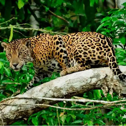
- Highlights: The transition from the Andes to the Amazon, the Cock-of-the-Rock, and the real possibility of seeing jaguars on the riverbanks.
- Key Wildlife: Jaguar (otorongo), tapirs, spider monkeys, and hundreds of endemic bird species.
- Time Factor: You need at least 4 to 6 days to truly take advantage of the Reserved Zone.
Analysis: Which best peruvian amazon region is right for you?
There is no single answer; it all depends on what you are looking for. Here we help you decide with objective criteria:
If you are looking for luxury and comfort:
Iquitos wins. Expedition cruises offer air conditioning, fine dining, and jacuzzis while you navigate the world’s largest river.
If you have little time and are coming from Cusco:
Tambopata wins. You can take a 40-minute flight from Cusco and be in a jungle lodge the same day. The quality/time ratio is unbeatable.
If your priority is pure, raw wildlife:
Manu wins. If you have the days and the budget, Manu’s Reserved Zone offers an experience of isolation and wildlife that few places on Earth can match.

Useful data for your trip to the jungle
Before booking your Peru jungle tours, keep these technical facts in mind that apply to all three regions:
- Climate: Humid tropical. Hot all year round.
- Temperature: Average of 28°C to 32°C.
- Humidity: Between 80% and 100%.
- Best Season:
- Dry Season (May to October): Less rain, less muddy trails, ideal for seeing macaws and animals on the banks.
- Rainy Season (November to April): Fruit on trees (more monkeys), high rivers (better navigation in creeks), but more mosquitoes.
- Altitude: It is lowland jungle, you will be below 500 meters above sea level (no altitude sickness!).
Expert Tips from Viajero Tours
As a local agency, we have seen it all. Here are our “hacks” to ensure your experience is safe and unforgettable:
- Clothing matters: Do not wear black (attracts mosquitoes) or neon colors (scares away animals). Use earth tones, olive green, or beige. Always long sleeves in breathable material (dry-fit).
- Vaccines: Although not always requested, the Yellow Fever vaccine is highly recommended (apply it 10 days before the trip).
- Binoculars: Many lodges lend them, but having your own ensures you don’t miss that howler monkey in the canopy. 8×42 is ideal.
- Disconnect: Most eco-lodges have limited electricity and little to no WiFi. Take the opportunity to listen to the jungle’s nightly symphony.
- Hydration: In the jungle, you sweat even if you don’t move. Drink water constantly to avoid headaches or dehydration.
Conclusion
So, which best peruvian amazon region is right for you?
- Choose Iquitos if you dream of the great Amazon River and pink dolphins.
- Choose Tambopata if you want to see incredible macaws and optimize your time from Cusco.
- Choose Manu if you seek total immersion in the most pristine nature on the planet.
Whichever your choice, the Amazon will transform you. At Viajero Tours, we know every corner, every lodge, and every travel time to design the perfect logistics for you.