Thursday, September 25, 2025

Tipón, Cusco: The hidden gem of Inca hydraulic engineering

Just 25 kilometers southeast of the city of Cusco, in the district of Oropesa, lies Tipón, one of the most impressive—and least visited—archaeological complexes in the South Valley. Unlike Machu Picchu or Sacsayhuamán, Tipón does not appear on mass tourist postcards, but for those who discover it, it becomes one of the most memorable experiences of their trip.

Tipon

What is Tipón?

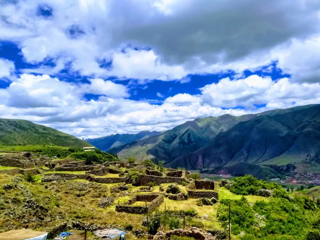
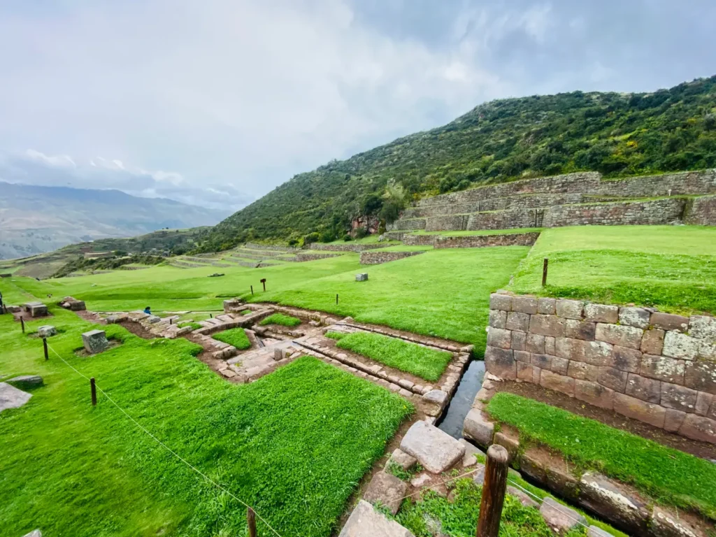
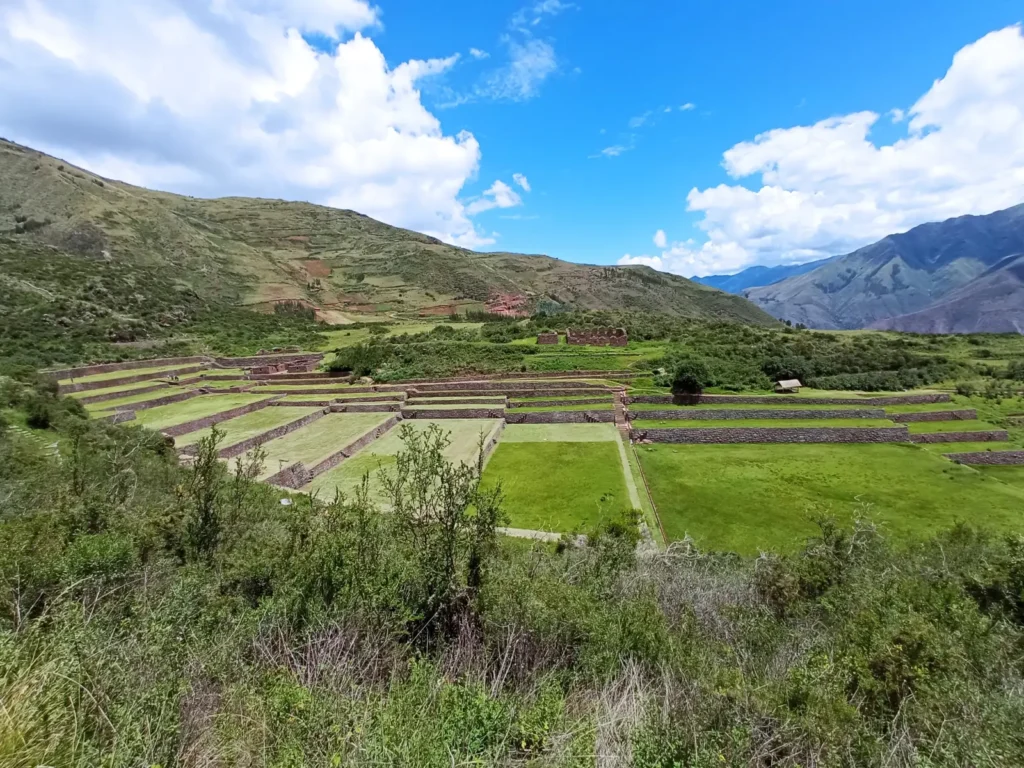
Tipón is an Inca archaeological site used for ceremonial, agricultural, and residential purposes, built on a steep hillside with a technical mastery that still dazzles today. What stands out most—and what makes it unique—is its system of canals and water sources that still function with precision to this day.

The Incas mastered water like few others. At Tipón, they not only controlled it: they celebrated it. The fountains flow with perfectly calculated pressure and direction, fed by a natural spring that Inca engineers redirected with underground tunnels and carved stone channels. The water is not wasted, it does not overflow, it does not stagnate. It is a living system, still in continuous operation after more than 500 years.

Tipon Terraces

Meaning and history

The name “Tipón” could derive from the Quechua word “t’ipuq,” which means ‘boiler’ or “place where water gushes forth,” in reference to its springs. Some researchers also suggest that it could have been a hydraulic laboratory or an agricultural experimentation center, where irrigation techniques were tested on terraces at different heights.

It is believed that Tipón was built during the reign of Yahuar Huácac or Viracocha Inca, and that it served as a royal residence or rest center for the Cusco nobility. Its strategic location, overlooking the valley and protected by hills, made it an ideal place for contemplation, ceremony, and agricultural administration.

Tipon

What you will see when visiting Tipón

As you explore the site, you will encounter:

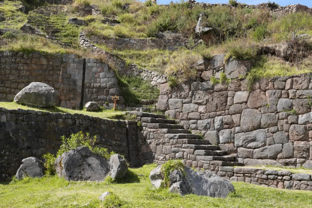
  • Twelve monumental agricultural terraces, perfectly aligned and with finely carved stone retaining walls.
  • Water channels that wind throughout the complex, some visible, others hidden underground.
  • Ceremonial fountains where water flows constantly, even in the dry season.
  • Stone enclosures and walls that suggest residential and administrative areas.
  • A natural viewpoint from which you can see the entire valley and the ingenuity of Inca design.

One of the most striking moments is to stop by the main fountain, close your eyes, and listen to the sound of water flowing continuously. It is a sensory experience that connects directly with the Andean worldview, where water is not a resource, but a deity.

tipon

How to get to Tipón?

Tipón is about a 45-minute drive from Cusco’s Plaza de Armas. You can get there by public transportation (buses going to Oropesa or Huacarpay), on an organized tour, or by private taxi. Admission is included in the Cusco Tourist Ticket (BTC), on circuit 2, along with Piquillacta, Andahuaylillas, and other sites in the South Valley.

The walk within the site is moderate, with some slopes, but accessible to most visitors. It is recommended to bring water, sunscreen, a hat, and comfortable shoes.

When is the best time to visit?

As with most archaeological sites in Cusco, the dry season (April to October) is ideal. The sky is clearer, the roads are dry, and the light is perfect for appreciating the details of the architecture and the shadows cast by the water channels.

If you visit during the rainy season (November to March), the landscape is greener and the fountains even more abundant, but you should be prepared for slippery roads and possible low clouds.

Why Tipón deserves to be on your itinerary

Tipón is not a place for quick selfies. It is a place to walk slowly, observe, listen, and learn. It is ideal for:

Furthermore, as it is on Tourist Ticket Circuit 2, you can easily combine it with other nearby destinations, such as the temple of San Pedro Apóstol de Andahuaylillas—known as the “Sistine Chapel of America”—or the ruins of Piquillacta, the administrative city of the Wari culture.

  • Those who seek to understand Inca engineering beyond giant stones.
  • Lovers of sustainable architecture and ancestral water management.
  • Travelers who want to avoid crowds and enjoy a peaceful archaeological site.
  • Students, researchers, or curious individuals interested in agriculture, hydraulics, or the Andean worldview.

Tips for your visit

  • Arrive early to enjoy the site without crowds.
  • Hire a local guide: many architectural and symbolic details go unnoticed without explanation.
  • Bring a bottle of water, even though the water there is drinkable—drinking directly from the ceremonial fountains is not allowed.
  • Respect the silence and energy of the place: Tipón was, and continues to be, a sacred space.

Conclusion

Tipón is much more than a series of terraces and canals. It is a living testament to Inca genius, a place where nature and architecture interact in perfect harmony, and where water—a sacred element—continues to flow as it did centuries ago. In a world where the old is often replaced by the new, Tipón reminds us that some solutions from the past were not only advanced, but also sustainable, beautiful, and deeply spiritual.

If you are in Cusco and want an authentic experience, far from mass tourism, Tipón should be on your list. You won’t regret it.

Tuesday, September 23, 2025

Q’eswachaka: The world’s last living Inca bridge

Deep in the Peruvian Andes, crossing the Apurímac River in the Cusco region, stands—or rather, hangs—a masterpiece of ancient engineering: Q’eswachaka. It is not just a bridge. It is a living symbol of cultural resistance, a collective ritual that is repeated every year, and the last tangible testimony to a tradition that the Incas spread throughout their empire.

What is Q’eswachaka?

Q’eswachaka—also spelled Q’iswa Chaka, Keswachaka, or Queshuachaca—is a suspension bridge made entirely of plant fibers, built and rebuilt each year by Quechua communities in the province of Canas, in Cusco. Its name comes from the Quechua words “q’iswa” (rope) and ‘chaka’ (bridge). Literally, “rope bridge.”

What makes it unique in the world is that it has been continuously built since pre-Hispanic times. Despite the arrival of the Spanish, modern roads, and steel bridges, these communities have kept the ancestral technique alive, passed down from generation to generation. In 2013, UNESCO declared it an Intangible Cultural Heritage of Humanity, recognizing not only the structure but also the community ritual that sustains it.

The annual ritual: more than just a construction project

Every June, thousands of people—including community members, local authorities, tourists, and curious onlookers—gather on the slopes of the Apurímac River to participate in or witness the annual reconstruction of the bridge. This event lasts four days and follows a precise, almost sacred ritual.

The process begins with the harvesting of ichu, a resistant Andean grass that grows at high altitudes. The women braid it into thin ropes, which the men then weave together to form the thick cables that will support the bridge. During the days of work, offerings are made to Pachamama, communal meals are shared, and songs are sung in Quechua invoking protection and strength.

On the last day, the new cables replace the old ones, and the bridge is stretched across the abyss. To close the ceremony, a party is held with music, dancing, and chicha, celebrating not only the completed work but also the collective identity that made it possible.

Where is it and how do I get there?

Q’eswachaka is located in the district of Quehue, province of Canas, in southern Cusco. It is about a 3.5-hour drive from the city of Cusco, passing through Sicuani. The road is unpaved in its final stretch, so a high-clearance vehicle or joining an organized tour is recommended.

The walk from the parking lot to the bridge takes about 20 minutes downhill—and the same amount of time, but with more effort, on the way back. The setting is spectacular: rugged mountains, the Apurímac River roaring below, and the bridge swaying gently in the wind.

Why is it important to visit?

Visiting Q’eswachaka is not just about crossing a bridge. It is about witnessing a living tradition, understanding how Andean communities have managed to preserve their knowledge in the face of modernity, and experiencing the power of collective work. Walking on its ropes, feeling how it moves under your feet, connects you with centuries of history.

What’s more, by visiting, you are directly supporting local communities. The entrance fee is symbolic (around 10 soles), and you can hire guides, buy handicrafts, or share a meal prepared by local families.

When to go?

If you want to experience the annual reconstruction, you should plan your trip for mid-June. The exact dates vary each year depending on the agricultural and lunar calendar, so it is advisable to confirm in advance.

Outside of this period, the bridge is open to visitors all year round. The dry season (April to October) is the most recommended: the roads are passable, the sky is clear, and the river, although imposing, does not pose any additional danger.

Q’eswachaka and the Inca legacy

The Incas built a network of roads—the Qhapaq Ñan—that linked their entire empire, from Colombia to Chile. In this system, suspension bridges were essential for crossing rivers and ravines. It is estimated that there were hundreds, perhaps thousands. Today, Q’eswachaka is the only one that remains with the original techniques and materials, thanks to the determination of four communities: Huinchiri, Chaupibanda, Choccayhua, and Ccollana Quehue.

This bridge is not a replica or a tourist attraction: it is an act of memory, resistance, and devotion. Each braided fiber is a thread that links the past and the present.

Tips for your visit

The altitude (over 3,700 meters above sea level) can affect those who are not acclimatized. It is recommended to spend at least one day in Sicuani or in higher areas before your visit. Bring warm clothes—the wind in the canyon is intense—water, snacks, sunscreen, and comfortable shoes.

If you plan to cross the bridge, take your time. It is about 28 meters long and hangs 30 meters above the river. Although it is completely safe—it is checked and tested every year—it can be intimidating for those who are afraid of heights.

Conclusion

Q’eswachaka is not a static monument in a history book. It is a living heartbeat of Andean culture, a lesson in sustainable engineering, and a reminder that some traditions deserve not only to be preserved but also celebrated. To cross this bridge is to cross centuries, to walk the same path as the Inca messengers, the chasquis, and to feel, even if only for a few seconds, the soul of a people who have never stopped weaving their own destiny.

Monday, September 22, 2025

Ausangate: Complete Guide to the Sacred Trek in the Peruvian Andes

Ausangate is not just a mountain. It is a whole world. A living territory, full of color, history, energy and pure nature. When you walk along its routes, you realize that every step leads you to discover something new: a lake that changes color, an animal that crosses the road, a community that welcomes you with a smile, or a hill that seems to watch over everything in silence.

This blog is your complete, optimized and easy to read guide to prepare, understand and live the Ausangate trek. No technicalities, no lists, no emojis. Just clear, useful and deep information, designed for you.

What is Ausangate trekking and why is it unique?

The Ausangate trek is a trek of several days in the Peruvian Andes, around the sacred snow-capped mountain of Ausangate. It is no ordinary hike. It is a profound experience, surrounded by landscapes that seem unreal: brightly colored lagoons, snow-covered hills, Andean animals such as llamas and vicuñas, and communities that have preserved their traditions for centuries.

This spiritual and natural trail attracts travelers from all over the world who are looking for more than just tourism: they are looking for connection, silence, beauty and challenge. The Ausangate trek is not done in one day. It is experienced in several days. And whoever experiences it, will never be the same again.

Trekking altitude: how to prepare for extreme altitude

This trekking takes place in a very high altitude area. The route passes through places ranging from 4,300 meters to 5,200 meters above sea level. The highest point is the Palomani pass, which is over 5,200 meters. That means the air has less oxygen, and your body needs time to get used to it.

It is very important to acclimatize before starting. It is recommended to spend at least two or three days in Cusco or in nearby towns such as Pitumarca or Tinqui, which are also at high altitude. Walking slowly, drinking plenty of water, eating light meals and avoiding alcohol helps a lot. Some people take coca tea or pills for altitude sickness, but the most important thing is to listen to your body. If you feel dizzy, with a headache or very tired, it is better to rest or go down a little.

The altitude of the Ausangate trek is one of its greatest challenges, but also one of its greatest lessons: it teaches you to go slowly, to breathe deeply, to respect your limits and to admire each step as an achievement.

How to get to Ausangate from Cusco: transportation and starting points

The Ausangate trek generally starts in the village of Tinqui. To get there, you must first go to Cusco, which is the nearest city with an airport and services for tourists.

From Cusco, there are two ways to get to Tinqui:

The first is to take public transportation. You can go to the Cusco bus terminal and look for buses or colectivos that go south towards Sicuani. Tell the driver to drop you off in Tinqui. The trip takes between three and four hours, depending on traffic and the road. It is economical, but not always comfortable.

The second option is to hire a tour that includes transportation from Cusco. Many travel agencies in Cusco offer complete packages that include mobility, guide, food, tent and horses to carry the luggage. This is the most recommended option if you do not want to worry about the details or if you are traveling alone. In addition, the guides know the route very well and help you with acclimatization and safety.

Getting to Ausangate is not complicated, but it requires planning. Book in advance, especially if you are traveling in high season (June to August).

Colored lakes in Ausangate: names, meanings and where to find them

The Ausangate lakes are famous all over the world. They are not ordinary lakes. They have colors that seem invented: bright turquoise, emerald green, deep blue, even reddish or silvery depending on the time of day. This is due to the minerals in the water and at the bottom, and also to how the sunlight reflects on them.

Ausangatecocha Lagoon: the sacred mirror at the foot of the snow-capped peak

It is one of the first you encounter on the trek. It is right at the foot of the sacred mountain, surrounded by snow and rocks. The water is an intense blue and reflects the summit as if it were a mirror. It is a very spiritual place, where the Andean people make offerings.

Laguna de los Colores (Vinicunca): the rainbow mountain

Although it is technically close to Ausangate and not within the main trekking circuit, many tours include it as an extra visit. It is famous for its colorful stripes on the ground: red, yellow, green, white, purple. It looks like it was painted by an artist. It is over 5,000 meters and is best seen in the mornings, when the sun illuminates it completely.

Pucacocha and Yanacocha Lagoon: mystical red and green tones

Pucacocha means “red lagoon”. Its color changes depending on the day, but it often has reddish or orange tones due to the minerals in the soil. Yanacocha, which means “black lagoon”, actually has a dark green or deep blue color. Both are in quiet valleys, ideal for resting and admiring the reflection of the hills.

Orccococha Lagoon and Quimsachata: turquoise and Andean serenity

Orccococha is one of the largest in the circuit. It has a bright turquoise color that contrasts with the white snow of the nearby hills. Quimsachata is a set of small connected lakes, with green and blue waters, surrounded by three snow-capped peaks. It is a magical place, very quiet, perfect to sit and take a deep breath.

Animals you will find in Ausangate: vicuñas, condors and more

The wildlife here is special. There are not many large animals, but the ones that are here are unique and beautiful. Most are accustomed to the altitude and cold, and live free, unafraid of humans.

Alpacas and llamas: companions on the road

They are the most common. You will see them grazing in herds, cared for by shepherds who live in nearby communities. Alpacas have softer and shaggier wool, llamas are taller and stronger, and are used to carry things.

Vicuñas: wild elegance in the high Andes

They are wild relatives of alpacas. They are thinner, elegant, with long necks and a shy look. They are protected by law, because their wool is the finest in the world. If you see one, stand still and admire it in silence.

Condors and foxes: guardians of heaven and earth

Condors are the largest birds in the Andes. They fly very high, taking advantage of cold air currents. If you see one circling above you, many say it is a good sign that the mountain is blessing you. Andean foxes are small, agile, gray or reddish fur. They are shy, but if you walk slowly and quietly, they can sometimes be seen at dusk.

You can also see viscachas (they look like rabbits with squirrel tails), Andean ducks and even flamingos in some salt lakes. Yes, flamingos in the Andes!

Andean communities of Ausangate: living culture and ancestral tradition

People are a fundamental part of this place. They are not only inhabitants, they are guardians. They take care of the land, respect the mountain and keep alive traditions that come from the Incas and even more ancient cultures.

Tinqui: gateway to trekking

It is the starting point for most trekking. It is a small village, with stone houses and thatched roofs. Here you can buy snacks, hire mules or meet the local guides.

Upis and Pacchanta: hot springs and hospitality

Famous for its natural hot springs. After days of hiking, bathing here is a gift from heaven. The hot water comes out of the ground and mixes with the cold mountain air. An Andean luxury.

Jampa and Pucará: weaving, history and spirituality

Jampa is a wide valley, ideal for camping. The people are very friendly and sometimes share coca tea with hikers. Pucará has an old church and is famous for its colorful weavings and unique designs. If you want to buy an authentic souvenir, this is a good place.

In all these communities, people speak Quechua, grow potatoes and corn, raise animals and weave alpaca wool. They live with the bare essentials, but with an enormous spiritual richness. If you smile at them, they smile back. If you thank them, they invite you to sit down. If you respect their way of life, they open their world to you.

Weather and best time to do the Ausangate trekking

The weather in Ausangate is extreme. During the day it can be hot and sunny, but in minutes it can be cloudy, rainy, hail or snowy. At night, it is always very cold, even in summer.

The best time to go is between April and October. These are the dry months. The skies are clearer, the roads are firmer and there is less risk of storms.

June, July and August are the coldest months, but also the most stable. If you don’t mind the cold, this is the best season.

Between November and March is the rainy season. The roads become muddy, the rivers rise and the sky is cloudy. It is not recommended to trek in this season, unless you have a lot of experience and adequate equipment.

Essential tips before trekking Ausangate

  • Don’t underestimate the altitude. Even if you are in good physical shape, the mountain tests you in a different way.
  • Respect local customs. Ask permission before taking pictures of people, greet them politely and accept what they offer you with gratitude.
  • Don’t leave trash behind. Everything you take with you, you bring back. Ausangate is sacred and we must take care of it.
  • Wear layered clothing. In a single day you can go from hot to bitter cold.
  • Don’t try to do it alone if you don’t have mountain experience. It is easy to get lost and the weather changes quickly.
  • Carry cash in soles. There are no ATMs or cards on the road.

Why Ausangate is not just a trek, but a life experience

The Ausangate trek is not just a walk in the mountains. It is a journey to the heart of the Andes, to the essence of a living culture, to the pure beauty of untouched nature. It is to walk where few walk, to see what few see, to feel what few feel.

It doesn’t matter if you don’t reach the highest point. What matters is what you learn along the way: patience, respect, gratitude, strength. And when you return, you bring with you something that cannot be bought: the memory of a mountain that looked at you, tested you, and let you pass, with a lesson for life.

If you are looking for a real adventure, with soul and depth, Ausangate is waiting for you. Calmly, respectfully, with an open heart.