Wednesday, April 1, 2026

Hiking Machu Picchu Mountain

Visitar la ciudadela inca es un sueño hecho realidad, pero verla desde las alturas es una experiencia que literalmente te dejará sin aliento. Mientras que la mayoría de las fotos clásicas muestran la montaña Huayna Picchu de fondo, la montaña sobre la que te paras para tomar esa foto es mucho más alta y majestuosa. Hablamos del desafío definitivo: el Machu Picchu Mountain hike.

Muchos viajeros llegan sin saber que esta caminata ofrece las vistas panorámicas más espectaculares de todo el santuario. Si buscas alejarte de las multitudes, conectar con la naturaleza y obtener una perspectiva de 360 grados de la geografía sagrada de los Incas, esta ruta es para ti. En esta guía, como expertos locales, te contaremos todo lo que necesitas saber para conquistar la cima.

¿Qué es la Montaña Machu Picchu?

Es importante no confundirse. Cuando compras tu entrada a la “Llaqta” (la ciudadela), estás visitando las ruinas. Sin embargo, rodeando la ciudadela hay dos picos principales: Huayna Picchu (el picudo que ves al fondo en las postales) y Machu Picchu Mountain (la inmensa montaña ubicada al sur, frente al Huayna).

La Machu Picchu Mountain elevation alcanza los 3,082 metros sobre el nivel del mar (10,111 pies). Esto la convierte en el punto más alto de toda el área arqueológica, superando por mucho a la ciudadela y al Huayna Picchu.

Detalles Técnicos: Dificultad y Tiempo

Antes de atarte las botas, es fundamental entender a qué te enfrentas. Aquí tienes los datos duros para planificar tu aventura:

  • Altitud de la cima: 3,082 m.s.n.m.
  • Desnivel: Ascenderás aproximadamente 650 metros verticales desde la ciudadela.
  • Machu Picchu Mountain hike time: El tiempo promedio es de 3 a 4 horas (ida y vuelta), dependiendo de tu ritmo físico.
  • Machu Picchu Mountain difficulty: Se considera moderada a desafiante. No requiere habilidades técnicas de escalada, pero sí una buena resistencia cardiovascular debido a la pendiente constante y la altitud.

La Ruta: ¿Qué esperar del sendero?

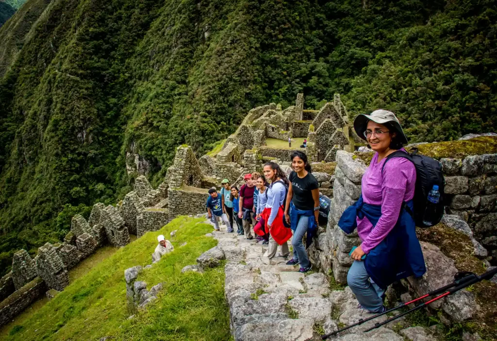
El Machu Picchu Mountain trail es un antiguo camino inca restaurado, compuesto principalmente por grandes escalones de piedra. A diferencia de otros senderos en la zona, este camino es más ancho, lo que lo hace menos aterrador para quienes sufren de vértigo.

A medida que asciendes, la vegetación cambia. Pasarás de la selva alta nubosa a una zona más abierta y soleada. Mantén los ojos abiertos, ya que es común ver orquídeas exóticas, aves coloridas y, con suerte, algún oso de anteojos a la distancia.

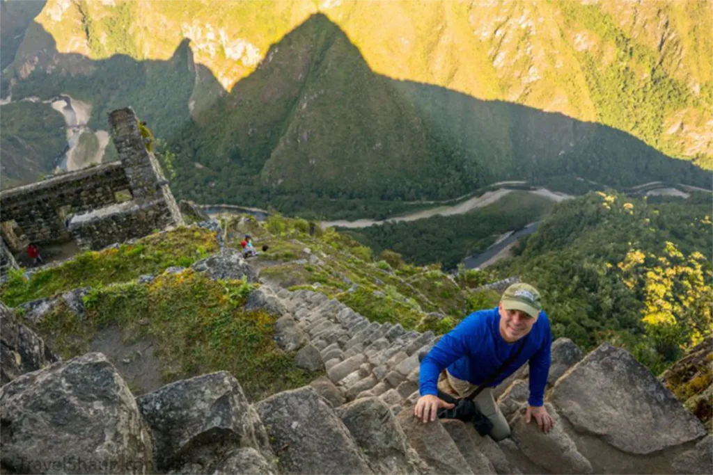
Una pregunta frecuente es: Is Machu Picchu Mountain worth it? (¿Vale la pena?). La respuesta es un rotundo sí. Al llegar a la cima, la recompensa es una vista inigualable. Verás la ciudadela inca como una pequeña maqueta allá abajo, el río Urubamba serpenteando alrededor como una serpiente de plata y la imponente cordillera de Vilcabamba con el nevado Salkantay vigilando el horizonte.

Machu Picchu Mountain vs Huayna Picchu: ¿Cuál elegir?

Esta es la duda más común entre nuestros viajeros. Aquí te ayudamos a decidir:

  1. Vistas: Hiking Machu Picchu Mountain te ofrece una vista panorámica superior y más completa que Huayna Picchu.
  2. Terreno: Huayna Picchu es más empinado, estrecho y puede causar vértigo (famoso por sus “escaleras de la muerte”). Montaña Machu Picchu es más larga, más alta, pero el sendero es más amplio y seguro.
  3. Arqueología: Huayna tiene algunas construcciones incas en la cima; Montaña Machu Picchu es puramente paisajística y natural.
  4. Multitudes: La Machu Picchu Mountain route suele estar menos congestionada, permitiéndote momentos de silencio y conexión espiritual que son difíciles de encontrar en Huayna.

Planificación: Entradas y Mejor Época

Saber how to hike Machu Picchu Mountain (cómo subir) empieza mucho antes de llegar a Cusco. Necesitas asegurar tu permiso.

Machu Picchu Mountain Tickets

Los boletos para esta montaña se venden por separado o como un “add-on” a circuitos específicos de la ciudadela. La disponibilidad es limitada (generalmente 400 espacios por día divididos en horarios).

  • Importante: Debes reservar con meses de antelación, especialmente si planeas viajar en temporada alta.

Best time to hike Machu Picchu Mountain

La mejor época es durante la estación seca, de mayo a octubre.

  • Horarios: Usualmente hay dos turnos de ingreso (ej. 7:00 AM y 9:00 AM). Recomendamos el segundo turno; a menudo las nubes de la mañana se disipan para cuando llegas a la cima, regalándote una vista despejada.

Consejos de Experto para subir la Montaña Machu Picchu

En Local Trekkers Peru, queremos que disfrutes cada paso. Aquí tienes nuestros Machu Picchu Mountain hiking tips para asegurar el éxito:

  • Aclimatación es clave: No intentes esta caminata el día que llegas. Pasa al menos 2 días en Cusco o el Valle Sagrado antes de subir.
  • El calzado importa: Usa botas de trekking con buen agarre. Las piedras pueden estar húmedas y resbaladizas, especialmente en zonas de sombra.
  • Lleva mucha agua: Al menos 2 litros por persona. La humedad y el esfuerzo te deshidratarán rápido.
  • Protección solar: Aunque esté nublado, la radiación UV en altura es extrema. Usa sombrero, gafas y bloqueador.
  • Usa bastones: Si tienes problemas de rodillas, los bastones (con punta de goma) serán tus mejores amigos en el descenso, que puede ser duro para las articulaciones.
  • Mochila ligera: Solo lleva lo esencial. El peso extra se sentirá el doble a 3,000 metros de altura.

Conclusión

El Machu Picchu Mountain hike es más que una actividad física; es una peregrinación hacia las nubes que te permite dimensionar la grandeza del Imperio Inca desde una perspectiva privilegiada. Si buscas un reto que combine historia, naturaleza y las mejores vistas de Perú, esta es tu montaña.

Inca Trail Location: Where This Iconic Trek Starts and Finishes

Machu Picchu is on everyone’s bucket list, but the journey to get there is just as legendary as the destination itself. If you are planning this once-in-a-lifetime adventure, understanding the specific Inca Trail location is the first step in turning your dream into a reality.

While most travelers know the trek takes place in the Andes, many are surprised by the diverse geography covered along the way. From arid Andean valleys to the lush cloud forest, knowing exactly where does the Inca Trail start and where it ends will help you prepare mentally and physically.

In this guide, Local Trekkers Peru breaks down the geographical details, the Inca Trail trekking route Peru, and what you can expect from the terrain on this ancient path.

Understanding the Inca Trail Location and Geography

Geographically, the classic Inca Trail is located in the Cusco region of southern Peru. It winds through the majestic Andes Mountains, specifically connecting the Sacred Valley of the Incas to the Amazonian cloud forest where Machu Picchu is hidden.

The Inca Trail route to Machu Picchu is not just a straight line; it is a historic network of stone paths laid by the Incas centuries ago. Because of its protected status as a UNESCO World Heritage site and part of the Historic Sanctuary of Machu Picchu, the route is heavily regulated to preserve its integrity.

Where Does the Inca Trail Start? The Famous KM 82

So, where does the Inca Trail start exactly?

The official starting point of the Inca Trail is known as KM 82. This location is named after the marker at the 82nd kilometer along the railway tracks leading from Cusco to Aguas Calientes.

Here are the key details about the start:

  • Location Name: Piscacucho (commonly referred to as KM 82).
  • Altitude: Approximately 2,600 meters (8,530 feet).
  • The Experience: This is where the KM 82 Inca Trail starting point checkpoint is located. You will present your passport and permit here. Once you cross the suspension bridge over the Urubamba River, your adventure officially begins.

Note: Some longer variations of the trek may start at KM 88, but the standard classic Inca Trail route details almost always focus on KM 82 as the beginning.

Inca Trail Itinerary Overview: The Path in Between

Between the start and the finish, the Inca Trail distance and route cover roughly 43 kilometers (26 miles). While that might not sound like a huge distance, the steep vertical gain and high altitude make it a challenging feat.

If you look at an Inca Trail route map, you will see the path snakes southward and then west, crossing high mountain passes before descending into the jungle.

Key Landmarks on the Route:

  1. Wayllabamba: The last inhabited village and usual campsite for Day 1.
  2. Dead Woman’s Pass (Warmiwañusca): The highest point of the trek at 4,215m (13,828 ft).
  3. Phuyupatamarca: Known as the “Town in the Clouds,” offering spectacular views.
  4. Wiñay Wayna: The most stunning archaeological site on the trail before Machu Picchu.

Where Does the Inca Trail End? The Sun Gate

After four days of hiking, where does the Inca Trail end?

Unlike the train travelers who arrive at the town of Aguas Calientes (Machu Picchu Pueblo), trekkers have the exclusive privilege of arriving directly at the citadel from above.

The official ending point of the Inca Trail is the Inti Punku (Sun Gate).

  • The Moment: Arriving at the Sun Gate is emotional. From here, you get your first panoramic view of Machu Picchu spread out below you.
  • The Final Stretch: From the Sun Gate, it is a short, downhill walk (about 45 minutes) to the Guardhouse, where you capture that classic postcard photo of the ruins.

Quick Facts: How Long is the Inca Trail and What to Expect

To help you prepare, here is a summary of the technical data regarding the Inca Trail location and difficulty:

FeatureDetail
Total Distance43 km / 26 miles
Duration4 Days / 3 Nights (Classic Route)
Starting Elevation2,600m (8,530 ft) – KM 82
Max Elevation4,215m (13,828 ft) – Dead Woman’s Pass
Ending Elevation2,430m (7,972 ft) – Machu Picchu
DifficultyModerate to Challenging
Best Time to GoMay to September (Dry Season)

Common Question: How long is the Inca Trail? While the classic trek is 4 days, there is also a “Short Inca Trail” option (2 days) that starts at KM 104.

Expert Tips from Local Trekkers Peru

As local experts, we know that knowing the map isn’t enough. Here are our top tips for mastering the Inca Trail trekking route Peru:

  • Acclimatize in Cusco: Do not head to the starting point of the Inca Trail immediately upon landing in Peru. Spend at least 2 to 3 days in Cusco or the Sacred Valley to adjust to the altitude.
  • Book 6 Months in Advance: Permits are limited to 500 per day (including porters and guides). If you want specific dates, you must book early.
  • Prepare for “Inca Flat”: Guides often joke about the trail being “Inca Flat.” This usually means rolling hills that are rarely actually flat. Train your legs for stairs!
  • Respect the Porters: They are the heroes of the trail. At Local Trekkers Peru, we treat our team like family, ensuring fair pay and proper gear. Always yield the way to porters on the trail.

Conclusion

The Inca Trail location offers one of the most diverse hiking experiences on the planet. From the dry scrub at KM 82 to the misty cloud forest at the Sun Gate, every step connects you to the history of the Andean people.

Knowing where does the Inca Trail start and end is just the beginning of your planning. Now that you understand the route, it’s time to secure your spot on this legendary path.